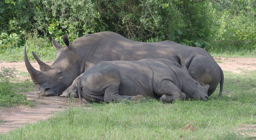
African Parks Rewilds 2,000 White Rhinos in Historic Conservation Move In a groundbreaking move hailed…
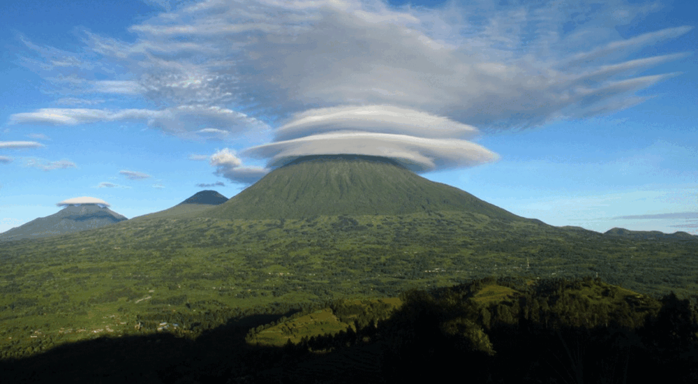
The Virunga Mountains
The Virunga Mountains, The beautiful Virunga Mountains are in East Africa. They are made up of three countries, Uganda, Rwanda, and Congo, and they are surrounded by volcanoes. The Virunga Mountains cover the eastern part of Virunga National Park in the Democratic Republic of the Congo and the western part of Mgahinga Gorilla National Park, also known as “where Gold Meets Silver.” In Rwanda, they cover the northwest corner of Volcanoes National Park.
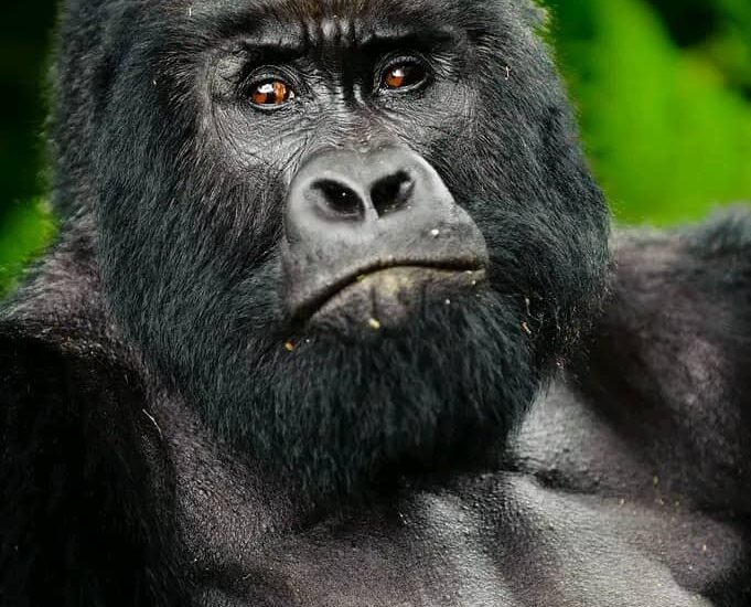
The word “Virunga” comes from the Kinyarwanda word “ibirunga,” which means “mountains.” It is also possible to call the Virunga Mountains the Virunga Massif. There are eight volcanoes in the Virunga Massif. They are spread out evenly between Uganda, Rwanda, and the DRC. Mountain Gorillas and Golden Monkeys that are still alive live in the Virunga Mountains.
In what places can you go monkey trekking?
Along the Albertine rift valley, the Virunga mountains are situated between Lake Kivu and Lake Edward. Most of the Virunga Massif get their names from the way they look. For example, Mount Sabinyo, also known as “the Old Man’s Teeth,” gets its name from the way it looks, which is like an old person’s tooth.
The highest mountain in the Virungas is Mount Karisimbi, at 4,507 meters (14,787 feet). Other mountains in the range are Mikeno, at 4,437 meters (14,557 feet), Mount Muhavura, at 4,127 meters (13,540 feet), Mount Visoke or Mount Bisoke, at 3,711 meters (12,175 feet), Mount Sabinyo, at 3,669 meters (12,037 feet), Mount Gahinga, at 3,473 meters (11,394 ft), Mount Nyiragongo, at 3,470 meters (11,380 feet), and Nyamuragira, at 3,058 meters (10,033 feet). All of the volcanoes in the Virunga Massif have been active in the past few years, but only Mount Nyiragongo and Mount Nyamulagira are still active and having volcanic outbursts. The most recent eruption on Mount Nyiragongo happened in May 2021.
The other six Virunga Mountains haven’t risen in a long time, so they are thought to be dormant. Out of the eight Virunga Mountains, Mount Sabinyo and Mount Mikeno are thought to be the oldest. This is because their crater lakes were empty about 2.6 million years ago, when they are thought to have formed.
Hiking in the Virunga Mountains, tracking the gentle giants known as mountain gorillas that live on the sides of these mountains, and many other things can be done in the Virunga Massif. Go to the nearby communities on the slopes, like the Batwa cultural communities, to learn more about their culture and take part in their activities, like cultural dances, golden monkey trekking, nature walks in the woods, bird watching, and more.
With its Virunga Massif
Mount Karisimbi is the highest point in the Virunga Volcanoes, at 14,787 feet. It is also the eleventh highest peak in Africa. A Kinyarwanda word called “amasimbi” means “snow,” which is how the mountain gets its name. In June, July, and August, snow covers the mountain. Mount Karisimbi is on the border between Rwanda and the Democratic Republic of the Congo.
A research center called Karisoke was set up by Dian Fossey to study mountain gorillas. Mount Karisimbi is close to this institute. It is possible to walk up Mount Karisimbi at any time of the year, but the best times are in June, August, or December, when you can see snow.
Mountains of Virunga
People who want to hike Mount Karisimbi don’t need to be expert mountain hikers. It takes two days to hike up Mount Karisimbi. In other words, on the first day you hike up the mountain and set up camp for the night. The next day you hike up to the top of Mount Karisimbi and enjoy the stunning views of Mount Nyiragongo, Mount Muhabura, and Mount Nyamulagira.
Finally, on the third day you walk down the mountain. Each person who wants to hike Mount Karisimbi needs to pay $400 for a hiking pass. You can get this hiking pass on the day of the hike, but it is better to book it ahead of time. The following hiking shoes are on the list of things to bring with you to hike Mount Karisimbi: Sunglasses, a hat, socks, bug spray, gardening gloves, a first aid kit, a tent, a walking stick, snacks, bottled water, warm sweaters, a rain jacket, and many other things.
Mount Mikeno is 14,577 feet high.
Mount Mikeno, which is 14,557 feet high, is the second tallest mountain in the Virungas. Mikeno comes from the word for “poor,” which comes from the mountain’s rough slopes, which don’t make it easy for people to live there. Instead, they are home to rare mountain gorillas. It is in the Democratic Republic of the Congo and is the 13th largest mountain in Africa. It is completely inside Virunga National Park. From the Bukima Patrol Post, where you’ll be told about gorilla climbing in Virunga National Park, you can see Mount Mikeno.
The mountains of Virunga
Hiking on Mount Mikeno is possible all year, but the best times are during the dry season (January through February and June through September). During these times, mountain gorillas are more likely to be seen on the trails, and the roads are less likely to be slippery. Hikers enjoy Mountain Mikeno because it is thought to be the hardest of the eight Virunga mountains to climb.
On Mountain Mikeno, you can do many things, such as gorilla trekking in the forests, hiking up the mountain, going on organized nature walks, bird watching safaris, and taking in the beautiful scenery. You will be able to see beautiful views of Mount Karisimbi, Mountain Nyiragongo, and Mountain Bisoke from the top of Mount Mikeno.
To walk Mountain Mikeno, you need to be an experienced hiker. The trip starts at the Bukima guard post and lasts for two days. The first night is spent at the Kabara Campsite. After that, on the second day, you hike to the top of Mount Mikeno, which takes four hours. You will go down the hills later.
Mount Muhavura is 13,540 feet high.
In Mgahinga Gorilla National Park, which is on the border between Uganda and Rwanda, you can find Mount Muhavura. The park is famous for being home to rare mountain gorillas and other primates like Golden monkeys. It is 13,540 feet high and is the third highest mountain range in the Virungas. The word Muhabura, also written as Muhavura, comes from the Kinyarwanda language and means “sentinel.” In the Rukiga language of Uganda, the word Muhabura means “the guide.”
The mountains of VirungaAs you walk up Mount Muhabura, you’ll get to see stunning views of Lake Ruhondo and Lake Burera, which are Rwanda’s two lakes. So, you can walk up Mount Muhabura from both Uganda and Rwanda. You can also get a good look at all three countries in the Virunga Massif from Mount Muhabura.
To climb Mount Muhabura, you have to pay $75 per person, which includes a guide. Mountain hiking on Mount Muhabura usually takes a full day from both countries, about 6 hours, depending on how fast the hikers go. They also need to be in good shape. Going on a hike up Mount Muhavura is one of a kind, and it lets people go on gorilla trekking safaris in Mgahinga National Park and Volcanoes National Park.
Mount Bisoke is 12,175 feet high.
Mount Bisoke, which is also called Visoke, is on the border between Rwanda and the Democratic Republic of the Congo. Its peak is in Rwanda, about 35 km northeast of Goma town, which is next to Lake Kivu. The mountain Bisoke is situated between the Rwanda Volcanoes National Park and the Virunga National Park in the Congo. Its steep sides are covered with equatorial jungles. The Swahili word for “soaked water” is where the name Bisoke comes from.
The mountains of Virunga
Mountain Bisoke is best hiked during the dry season, when it is easy. The wet season, from September to June, is when it is muddy. Since Mount Bisoke is the easiest mountain in the Virunga Massif to climb, it is also the most popular. It has trails that lead to two different lakes, one at the base and one at the top.
Mount Sabinyo is 12,037 feet high.
Ghana, Rwanda, and the Democratic Republic of the Congo are all close to Mount Sabinyo. But you can see and walk up this Virunga volcano best from the Uganda side. The Rwanda and Congo sides are very steep and have sharp ridges.
The name Sabinyo comes from the local word Irinyo, which means tooth. This is because the top of Mount Sabinyo looks like a gum full of worn-out teeth. The dry season runs from December to February and June to September. The best times to hike Mount Sabinyo are during these times. The fee to walk is $80 per person. In addition to hiking up the mountain, trekkers can do exciting things like gorilla tours, golden monkey tours, tours to the Garama caves, bird watching trips, the Batwa trail experience, and more.
11 394 ft. high Mount Gahinga
Mount Gahinga is the least difficult to climb out of Mount Muhabura and Mount Sabinyo. Its name comes from the Kinyarwanda word Gahinga, which means “pile of stones.” One of the dormant Virunga volcanoes is Mount Gahinga. The Virunga range is in Uganda, Rwanda, and the DR Congo.
Trekkers who go on the hike to Mount Gahinga may see the mountain gorilla, the golden monkey, the vervet monkey, the blue monkey, the black and white colobus monkey, and other kinds of monkeys. You might also see buffalo, warthogs, hyenas, lions, and other animals. There are also many kinds of birds. Mount Gahinga is 3,474 meters above sea level and is shared by Volcanoes National Park in Rwanda and Mgahinga Gorilla National Park in Uganda.
Mount Nyiragongo is 11,380 feet high.
Alive volcano Mount Nyiragongo is in Virunga National Park in the Democratic Republic of the Congo. It is 1180 feet above sea level and 20 km from both Goma town and Lake Kivu. There is a lot of wildlife on the slopes of Mount Nyiragongo, like bushbuck and chimps. The Kibati guard post is where the hike to the top of Mount Nyiragongo volcano starts.
It takes two days of hiking to reach the top of Mount Nyiragongo, but some hikers say it should take three days. More than 35 times, Mount Nyiragongo is said to have exploded. The most recent time was in May 2021. It takes $326 to get a permit to hike up Mount Nyiragongo in the Congo. For hiking Mount Nyiragongo, you should bring a sleeping bag, a camera, a tourist visa, enough water, climbing boots, a raincoat, bug spray, and other things. Mount Nyiragongo is best hiked during the dry season, which runs from June to October and December. However, it can be seen at any time of the year.
Big Nyamuragira Mountain (10,033 feet)
Mount Nyamuragira is only 14 kilometers northwest of Nyiragongo, which is the world’s most active volcano, and 25 kilometers west of Lake Kivu. Nyamulagila is another name for the lake where liquid magma flows safely. The name of Mount Nyamuragira comes from a nearby Kinyarwanda word, Kuragira inka, which means “crowd cows.”
Mount Nyamuragira has released Aldo at least a few times since 1885; the most recent time was on November 8, 2011. Only a few volcanoes have kept their lava lakes for a very long time. Mount Nyamuragira is one of them. Between June and August 2014, a 500-meter-deep new magma lake formed. This lake will continue to grow and change magma streams in the future.
You can see the caldera and other mountains that were made by the eruptions if you hike up Mount Nyamuragira. But most of these mountains have gone away over time for no clear reason. As you start your walk, you will be able to see a lot of different kinds of wildlife, as well as the rewarding sights and interesting views of Mount Nyiragongo and Mount Mikeno.
Related Posts